


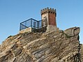


Photo: Samuele on English Wikipedia Samuele nella Wikipedia Italiana, Public domain · Wikimedia Commons
At a glance
- Type
- Lighthouse
- Period
- Modern era, 1844
- Coordinates
- 42°51′54″ N, 10°28′30″ E
History and description
Palmaiola Lighthouse (Italian: Faro di Palmaiola) is an active lighthouse, placed on the summit of the same name islet, in the Tuscan Archipelago between Piombino and Elba in Rio Marina.
History
The Pisans built on the islet a watch tower in 909 which was restored by Jacopo V Appiano of the Principality of Piombino in 1534; a new lighthouse and the keeper’s house were inaugurated on January 15, 1844, and were operated by the Civil engineering for the Maritime Works; in 1911 the light was transferred to the Regia Marina Lighthouse Service.
Description
The lighthouse consists of one-story white building, surmounted by a quadrangular tower, 14 metres height, with gallery and lantern situated at 105 metres above sea level. The light is active, fully automated and operated by Marina Militare identified by the code number 2016 E.F. Near the building a helipad was erected and used by the Marina Militare EH-101 to fly in regularly the maintenance team. The lighthouse has a solar power unit and emits an alternating single white flashing in a five seconds period visible up to 10 nautical miles.; in 2008 underwent to renewal works.
Text from Wikipedia, the free encyclopedia, under CC BY-SA 4.0. Full article: «Palmaiola Lighthouse».
Timeline
- 1844Built
Events and people from Wikidata (CC0).
Photos
Getting there
PiombinoTrain, nearest
8.1 km as the crow flies
Palmaiola Lighthouse
Port4.2 km
Aeroporto di Marina di Campo22.4 km
Distances are as the crow flies, not walking or driving.
Loading map…
Nearby
See on the mapMore lighthouses in Tuscany


Frequently asked questions
Where is Palmaiola Lighthouse?
Palmaiola Lighthouse is in Rio, in the province of Livorno (Tuscany), Italy. GPS coordinates: 42.86500, 10.47500.
How old is Palmaiola Lighthouse?
Wikidata dates it to 1844.
What else is there to see near Palmaiola Lighthouse?
Nearby you’ll find: Villa romana di Capo Castello (4.4 km away), Fortezza del Giove (5.7 km away), Grassera (6.5 km away).
Sources and licences
Text. Wikipedia, the free encyclopedia (CC BY-SA 4.0).
Data. Wikidata (CC0); opening hours and contacts OpenStreetMap (ODbL).
Photos. Wikimedia Commons, author and licence on every image.
Credits for the 8 photos
- Palmaiola island - northern rock and lighthouse — Samuele on English Wikipedia Samuele nella Wikipedia Italiana, Public domain
- Palmaiola island - lighthouse — Samuele on English Wikipedia Samuele nella Wikipedia Italiana, Public domain
- Isola di Palmaiola, dalla spiaggia di Topinetti - panoramio — Carlo Pelagalli, CC BY-SA 3.0
- Palmaiola island - front view — Samuele on English Wikipedia Samuele nella Wikipedia Italiana, Public domain
- Palmaiola island - panorama — Samuele on English Wikipedia Samuele nella Wikipedia Italiana, Public domain
- Palmaiola's gull — Mattia Luigi Nappi, CC BY-SA 3.0
- Piazza Bovio con Elba001 — Costaetrusca (Roberto Baroni), CC BY-SA 4.0
- Piazza Bovio e l'isola d'Elba — Nonno 2 luciano, CC BY-SA 4.0
Updated 28 October 2026. All sources and licences