


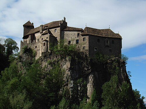
Photo: Llorenzi, CC BY-SA 3.0 · Wikimedia Commons
Castle, 1200
Jaufenburg
Building in St. Leonhard in Passeier, South Tyrol, Italy
At a glance
- Type
- Castle
- Period
- Middle Ages, 1200
- Area
- 150 m²
- Protection
- Cultural heritage monument in South Tyrol
- Coordinates
- 46°48′55″ N, 11°15′09″ E
- Address
- Via Castello 45, San Leonardo In Passiria
About
No English description yet
Opening hours and directions are on this page. The full story is on Italian Wikipedia.
Read it in ItalianTimeline
- 1200Built
Events and people from Wikidata (CC0).
Photos
Getting there
Address
Via Castello 45, San Leonardo In Passiria
Our data shows no stations, stops or car parks nearby. Check how to get there before you set out.
Loading map…
Nearby
See on the mapMore castles in Trentino-South Tyrol



Frequently asked questions
Where is Jaufenburg?
Jaufenburg is in Sankt Leonhard in Passeier, in the province of Bolzano (Trentino-South Tyrol), Italy. Address: Via Castello 45, San Leonardo In Passiria. GPS coordinates: 46.81518, 11.25248.
How old is Jaufenburg?
Wikidata dates it to 1200.
What else is there to see near Jaufenburg?
Nearby you’ll find: MuseumPasseier (1.8 km away), South Tyrolean Museum of Hunting and Fishing (11.4 km away), Reifenegg Castle (11.6 km away).
Sources and licences
Data. Wikidata (CC0); opening hours and contacts OpenStreetMap (ODbL).
Photos. Wikimedia Commons, author and licence on every image.
Credits for the 5 photos
- CastelGiovoPassiria — Llorenzi, CC BY-SA 3.0
- Jaufenburg - Flickr - Stiller Beobachter — Stiller Beobachter from Ansbach, Germany, CC BY 2.0
- Jaufenburg von oben — Svíčková, CC BY-SA 3.0
- Passeiertal 2013 002 — Klaus Graf, CC BY-SA 3.0
- St. Leonhard in Passeier 04 — Thomas Hummel, CC BY-SA 4.0
Updated 28 October 2026. All sources and licences