Saved
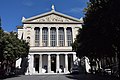
Sistine chapel
Original photo1 of 5 photos

Photo: Sailko, CC BY 3.0 · Wikimedia Commons

Museum, 1481

Sistine chapel

Chapel in Savona, Italy

Savona (SV), Liguria

Directions

At a glance

Type
Museum
Period
Middle Ages, 1481
Style
Rococo
Protection
Italian national heritage
Coordinates
44°18′28″ N, 8°28′57″ E
Address
Piazza Duomo 1, 17100 Savona

About

No English description yet

Opening hours and directions are on this page. The full story is on Italian Wikipedia.

Read it in Italian

Timeline

  1. 1481Founded

Events and people from Wikidata (CC0).

Photos

Getting there

SavonaTrain, nearest
900 m as the crow flies
Sistine chapelPiazza Duomo 1, 17100 Savona
Savona Terminal Auto srl1.0 km
Aeroporto Internazionale di Genova - Cristoforo Colombo30.9 km

Distances are as the crow flies, not walking or driving.

Loading map…

More museums in Liguria

See all museums in Liguria

Things to see in Savona: 76 historic places

Frequently asked questions

Where is Sistine chapel?

Sistine chapel is in Savona, in the province of Savona (Liguria), Italy. Address: Piazza Duomo 1, 17100 Savona. GPS coordinates: 44.30787, 8.48258.

How old is Sistine chapel?

Wikidata dates it to 1481.

What else is there to see near Sistine chapel?

Nearby you’ll find: Palazzo Della Rovere (100 m away), Palazzo Gavotti (100 m away), Museo d'arte di Palazzo Gavotti (100 m away).

Sources and licences

Data. Wikidata (CC0); opening hours and contacts OpenStreetMap (ODbL).

Photos. Wikimedia Commons, author and licence on every image.

Credits for the 5 photos
  1. Savona, cappella sistina 01 — Sailko, CC BY 3.0
  2. Savona - Cappella Sistina (2) — Luca Galli, CC BY 2.0
  3. Savona-cappella Sistina — Antonello Piccone at Italian Wikipedia, CC BY-SA 3.0
  4. Cappellasistina savona — The original uploader was Antonello Piccone at Italian Wikipedia.; listed there as own work., Public domain
  5. Savona - Via Ambrogio Aonzo - Il Duomo - Sistina Cappel - panoramio — Andrea Albini, CC BY-SA 3.0

Updated 28 October 2026. All sources and licences

Spotted a mistake? Fix it on OpenStreetMap